1.800.336.5437
Low Price GuaranteeTrack OrderWish ListEZ ReturnsMonday through Friday 7am to 7pm Saturday 8am to 4pm
- MOUNTAIN TIME
- ¡Hablamos español!


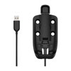
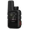
Garmin inReach Explorer+

- View Larger
- Video
Garmin inReach Explorer+
176154People who have viewed this item have also viewedSee all GPS/Navigation
Additional Videos

Garmin InReach Explorer and SE GPS Devices

Garmin inReach SE+ & Explorer+
Garmin InReach Explorer and SE GPS Devices
Details
If you ride your machine in unfamiliar territory and remote trail systems, taking the Garmin inReach Explorer+ is one of the best things you can do to make sure you stay safe and give your loved ones peace of mind. Designed to be one of the best premium, hand-held satellite communicators, the Explorer+ has location sharing, navigation, and life-saving SOS signaling to keep you safe and in touch literally anywhere in the world. The premium Explorer+ also boasts unique features including preloaded Delorme® TOPO maps with onscreen GPS routing, a built-in digital compass, barometric altimeter, and accelerometer.Garmin also gives the Explorer+ a support system of 100% global Iridium satellite coverage, providing you 2-way text messaging that can be used to send custom messages or stock/canned responses to let people know you’re alright, still on route, etc. The Explorer+ can also track your location along the trail and share your position, letting your spouse / family track your progress at a glance. In extremely critical situations, an SOS signal can be triggered to alert emergency responders at a 24/7 search and rescue monitoring center—ensuring you get help when you need it most. But, Garmin works to make dangerous situations less likely when you pair the Explorer+ with your phone or mobile device and use the Earthmate® app to access downloadable maps, U.S. NOAA charts, color aerial imagery, and more.
Which inReach Is Right for You?
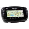
As satellite communicators, both the inReach SE+ and Explorer+ offer identical messaging capabilities. However, it’s on the GPS navigation side that their differences become apparent. While inReach SE+ uses GPS to provide basic grid navigation and allow you to drop waypoints, mark key locations, track your progress, and follow a breadcrumb trail back to base – the inReach Explorer+ goes a step beyond, providing full-fledged GPS on-map guidance with preloaded TOPO mapping and waypoint routings viewable directly on the unit. Plus, a built-in digital compass, barometric altimeter and accelerometer are included with Explorer+ to help you get and maintain accurate bearings anywhere on or off the beaten path.
Features
- Wireless compatibility (Bluetooth®)
- Trigger an interactive SOS with 24/7 search and rescue monitoring center
- Send and receive text messages to SMS and email
- Send and receive messages with other inReach users and exchange locations
- Track and share location with friends and family on web-based MapShare® portal
- Request weather forecasts for current location and planned destination
- Virtual keyboard for custom text messaging
- Send waypoints to MapShare portal during trip
- Send route selection to MapShare portal for friends and family to see progress
Dimensions & Tech Specs - Physical dimensions: 2.7" x 6.5" x 1.5" (6.8 x 16.4 x 3.8 cm)
- Weight: 7.5 oz (213.0 g)
- Water rating: IPX7. Suitable for: Splashes, Rain or Snow, Showering, or incidental exposure to water of up to 1 meter for up to 30 minutes.
- Battery: Rechargeable internal lithium ion
- Display type: transflective color TFT
- Display size: 1.4"W x 1.9"H (3.5 x 4.7 cm); 2.31" diag (5.9 cm)
- Display resolution: 200 x 265 pixels
- High-sensitivity receiver
- Interface: USB
- Battery life:
-Up to 100 hours at 10-minute tracking mode (default)
-Up to 75 hours at 10-minute tracking with 1-second logging
-Up to 30 days at the 30-minute interval power save mode
-Up to 3 years when powered off
Sensors - Barometric altimeter
- Compass tilt-compensated 3-axis)
Maps & Memory - Memory/History: 2 GB
- Ability to add maps
- Waypoints/favorites/locations: 500
- Routes: 20
- Preloaded maps: Explorer+ comes preloaded with a 1:24k map of Garmin Yarmouth (Former DeLorme) North America data of the U.S. and Canada. Mexico also is included at a 1:125k scale (derived from Garmin Yarmouth’s Digital Atlas of the Earth).

Garmin inReach Explorer+ Reviews
 Each review submitted enters you into a
$100 gift card monthly drawing and a
$500 gift card quarterly drawing!
Each question or answer submitted enters you into a:$100 gift card monthly drawing and a
$500 gift card quarterly drawing!